Friday, February 26-March 6, 2016
With Leah's permission, I'm going to begin using chunks of her daily journal as text in this blog. She wrote them every day, so they retain the flavour and detail of that day, which would be impossible for me to recreate months later. Thanks, Leah.
We were at the Texas Springs campground just outside the town of Furnace Creek, CA, and inside Death Valley National Park, where, on Friday, Feb. 26, Leah wrote the following:
"Got up very early because the people on the other side of us were packing to leave. I am tired of this close quarter living. Also not cooling off as much at night. The forecast for the weekend is high 80s, too hot for us, so we too have decided to leave….instead of doing laundry, which was our plan. Still lots of places to explore here but the heat and the close quarters in the campground make it not that appealing. Have learned that we were very fortunate to experience the ‘superbloom’ here. This has been the best wildflower season in 11 years and so it is far more crowded than it would normally be at this time.
We dumped, filled and left Furnace Creek without eating breakfast. The drive to Lone Pine was truly incredible!!! Sometimes when we are on main roads that are paved we don’t appreciate the splendour as much as when we are on back unpaved roads. …perhaps because you can go so much faster. Anyway, this one was terrific. Beautiful road with spectacular views and then we got to a dried up, salt lake with a number of abandoned places. What I haven’t yet mentioned is that the snow capped Sierra Nevada Range is visible on the horizon to the left of the road and getting closer.
 |
| On Hwy 136 to Lone Pine, from Furnace Creek. Sierra Nevada Range on left. |
 |
| Abandoned cabin on the way to Lone Pine |
 |
| Another view of the cabin, roof caved in. |
From Leah's journal:
"Finally got to the town of Lone Pine. Stopped at the Visitor’s Centre, got directions to Tuttle Creek Campground and was freaked out by all the ‘active bear’ warnings. Drove thru the town first, which looked small but interesting."
"Tuttle Creek campground is almost at the foot of the mountains. It costs $5 a night and had a number of campers, mostly RVs in one area. The most scenic loop was closed, but truthfully, there isn’t a bad site here. We chose a pull thru with better solar prospects than most, and away from all the RVs. Because it is Friday, we were concerned that it would get busy, and yes, more people came…mostly in truck campers and tents, but for the most part, it is pretty empty. It is very quiet. We have only heard 2 generators for short periods of time and they are quite a ways away. This is bear country, ‘active bear country’, and that makes me anxious, but it is so beautiful here. We have an unobstructed view of the snow capped mountain range, lots of sage covered high desert in every direction, the rocks of the Alabama Hills and also the dried lake bed, which in fact has wet spots that reflect light. The lake is also surrounded by distant mountain ranges which turn red when the sun sets. Truly remarkable in every direction."
 |
| Our campsite at Tuttle Creek Campground, 5 miles from Lone Pine. Inyo Mtns behind us. |
 |
| Closer look. |
 |
| Owens Dry Lake Bed from our campsite, Tuttle Creek Campground |
 |
| Nestled against the Sierra Nevada Range at our Tuttle Creek camp site. |
 |
| Owens Dry Lake Bed at sunset from our Tuttle Creek campsite. |
The Alabama Hills
From Leah's journal:
"Tuttle Creek Campground is about 5 miles out of Lone Pine. We had to first drive thru the Alabama Hills. This is a series of hills covered in boulders of many shapes and colours….kind of like City of Rocks [campground in New Mexico], but really like nothing I have ever seen before. It is desert, with the Sierras behind it, but these rocks, with numerous dirt roads winding around them, are very picturesque and plentiful. In fact so many westerns have been filmed here that the main road is called Movie Flat Road."
We explored the Alabama Hills for most of the next day, starting at about 5:15 AM, when I drove over there to catch Mobius Arch at sunrise.
 |
| Mobius Arch, which I'd hoped to shoot with pink sky at sunrise...but nature didn't cooperate. |
 |
| Still a nice show, though. |
 |
| The sunrise colours were in the east today. |
 |
| Early morning looking west in the Alabama Hills. Sierra Nevada range in the distance. |
From Leah's journal:
"Richard got up at 5:15 so he could go to Mobius Arch and take pictures. I woke up a little later when he was making toast. I heard him leave and lock the door. I didn’t go with him because I thought that this was something he wanted to do on his on. I decided to watch the sunrise from here, so I got out of bed, made coffee, bundled up and sat/walked around outside enjoying the light show. The air was crisp, the light hazy over the dried lake and pink on the snow caps. When I was ready to go in, at about 6:45, I discovered that when I went out, only one of the locks had unlocked and when I shut the door, the other lock caught. I was locked out! No book, no phone, no game….nothing to do. …a very novel and interesting predicament in this technological age. I am so used to occupying my time. I also did not have my walking shoes or my knee and back stuff…so a long walk was also out of the question. I was warm and I had my coffee. I sat in my chair and watched and listened. Very enjoyable, but I had no idea when P would return. The earliest I thought would be about 8:30, but perhaps it would be longer…or maybe he would go to town and have breakfast. In any case, I was outside. The guy from across the road talked to me for a while. He was a ham radio operator and told me about some of the interesting sights around here. I was about to go on my first real stroll around the campground, hoping to meet the lady in the truck camper in the back, when P drove up…about 7:30. We had a small breakfast and then we went back into the Alabama Hills and walked the Mobius Arch trail together.
 |
| Hike in the Alabama Hills |
 |
| Hike in the Alabama Hills |
 |
| Hike in the Alabama Hills. Looked like an ogre with a necklace. |
 |
| Leah skirts the ogre. |
 |
| Hike in the Alabama Hills |
 |
| Hike in the Alabama Hills |
 |
| Hike in the Alabama Hills |
 |
| Hike in the Alabama Hills |
 |
| Hike in the Alabama Hills |
Glacier Lodge Road hike
From Leah's journal:
"We drove to Big Pine, the place where the ranger said there was a road open into the mountains. We drove up Glacier Lodge Road which was quite picturesque as it climbed through snow covered peaks. We stopped at Glacier Lodge, a small campground and a number of cabins perched beside a rushing mountain stream and in the shadow of Palisade Glacier and another glacier as well. We walked to First Falls which was beautiful. We followed a mountain trail hoping to get to Second Falls, but the path became snow and ice covered, and after about 15 minutes of slow careful walking, we went back.
 |
| Small pond at Glacier Lodge, in the Sierra Nevada |
 |
| At First Falls, on trail. |
 |
| Heading up... |
 |
| Trail deteriorated to snow and ice. |
Manzanar
Just up the road a few miles from our camp at Tuttle Creek was Manzanar National Historic Site. Manzanar is a WW2 Japanese-American internment camp—the government used the words “War Relocation Camp”. It is operated by The National Park Service, which did significant archeological work on the camp, reconstructing several buildings, and creating an informative Visitors Center. We discovered it on the way back from the Glacier Lodge hike. It was about 5 PM on an overcast day, magic hour at this time of year, and the buildings were closed, but you could drive around the 6200 acre site and see whatever was outside: namely, a rock garden (once with water in it) built by the internees, a cemetery, the remains of a vegetable garden, and the sites of the many barracks, as well as miles and miles of flat, deserted scrub land. Pretty desolate. However, Manzanar sits at the base of the majestic, snow-covered Sierras, imparting to the bleakness an odd, muted beauty.
As we drove slowly through this silent, abandoned place, getting out and reading the information plaques, we knew injustices had occurred here…and yet the internees—10,000 in this camp alone, 120,000 in 10 camps across the US, according to Wikipedia—managed to create beauty, like a small park, and a rock garden with a waterway, even in the midst of the awfulness that must have been their lives. These internees were ordinary citizens: mechanics, fishermen, factory workers, professional, husbands, wives, whole families--who'd done nothing wrong. And yet they lost all their worldly possessions and were imprisoned in this bleak, yet beautiful desert mini-city. So much for the Constitution. Of course, it's probably true that this mass incarceration did protect the internees from attacks and violence from some of their neighbours. This was one of the government's justifications for moving them to camps. Still, I'm sure there were less draconian ways to keep them safe--and in their own homes.
Here is Leah's impression from her journal, after our drive through the grounds: "On the way back to the campground we passed the site of Manzanar, an old Japanese ‘Relocation’ camp, and decided to go in and look around even though the Visitor Centre was closed. It housed 10,000 people and was one of 10 camps in the US. It was very desolate, although I think at the time there was more water and more growth. We took the self driving tour and saw the restored remains of a number of interesting locations. It was very extensive and in my opinion the signs tried to whitewash what happened there. They focussed on how life went on normally with a newspaper, store, factory, baseball field and clubs, but there was also a lot of barbed wire and a guard tower probably manned by soldiers with rifles. I had the same feeling walking thru there that I had when I visited the concentration camp in France…..a lot of misery once filled this place. However, it was inspiring to see how the detainees were able to create beauty with lovely gardens, ponds, carvings and sculptures. At the graveyard there was a white stone which said: Soul Consoling Tower."
A few days later, we revisited Manzanar, and were able to tour a reconstructed barracks, and the Visitor Center, a very large gymnasium-like building. It tells the story of the camp using movie and audio footage, and reconstructed rooms, barracks and mess hall, as well as the recorded experiences of 4 Japanese Americans who were interned there. In addition, there are video interviews with 6 or 8 surviving former internees. My overall impression after watching the video-taped interviews with the survivors, was that they felt that their adopted country had treated them very poorly--had made a huge mistake. But in spite of all their suffering, most still seemed able to forgive and move on. Very little bitterness. One thing they all agreed on, however, is that they don't want the country to forget.
Here is a Dorothea Lange photo of Manzanar in 1942:
 |
| Manzanar, Calif.--Street scene looking east toward the Inyo Mountains at this War Relocation Authority center. The children are coming to their barrack homes from play school. Each family has one room to live in in these barracks. There is no running water in the barracks so all the families in one block use a central bath house. The barracks are heated by wood burning stoves. -- Photographer: Lange, Dorothea -- Manzanar, California. 6/29/42 |
Today, only a reconstructed barracks, Visitors Center, guard tower, guard house, and mess hall still stand.
Here is the entrance today:
 |
| Entrance to Manzanar today. Guard house built by internee |
Inside the reconstructed barracks:
 |
| Inside one end of a reconstructed barracks. |
Here (below) is the inside of a barracks in 1942. Photo by Dorothea Lange:
 |
| Hanging sheets provided some privacy. |
 |
| This bridge once crossed a meandering waterway, and was part of Merritt Park, a 1 & 1/2 acre park that included lawns, walkways, and trees, all built entirely by internees. |
 |
| This was part of the meandering waterway. |
 |
| Merritt Park, as it looked in 1943 |
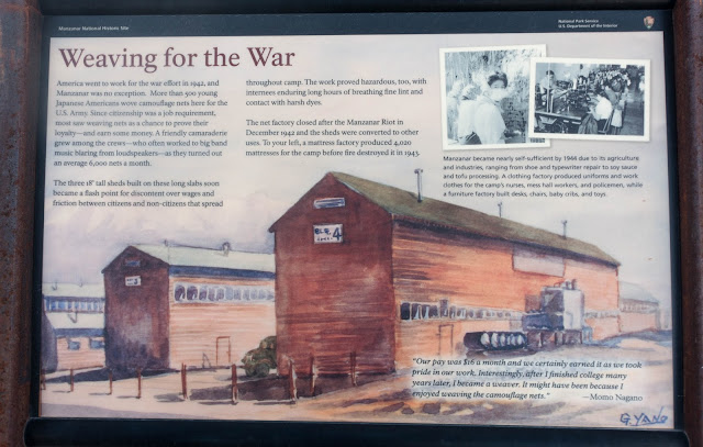
Here is a factory that employed many at Manzanar. It made camouflage nets for US soldiers.
Here is the cemetery at Manzanar, where between 15 and 80 people were buried:
 |
| The writing on the obelisk says, "Soul Consoling Tower" |
See that semicircle of wood stumps connected by rope that surrounds the obelisk on three sides? Here's a close-up of one of the stumps:
It's actually made of concrete...to look like wood. A famous Japanese sculptor was interned at Manzanar; he created all of them by hand. They really do look exactly like wood! This same man was a stone mason and built the guard house structure in the entrance picture 8 photos back.
For me, visiting Manzanar was a moving experience. I suggested to the Rangers that they invite Donald Trump and Ted Cruz. Later, I discovered in a visitor’s book that I was not alone in that opinion.
 |
| From the visitor's book. |
Click
here to open a page with photos of Manzanar by Dorothea Lange.
Next post: Cerro Gordo ghost town and Mono Lake, California
 |
Click here to Reply or Forward
|


No comments:
Post a Comment